Indigenous Mapping Network
Introduction: Remote Sensing in Indian Country

Remote Sensing
Last Updated on Sunday, 26 September 2010 20:06 Written by Laurie Ames, Remote Sensing Specialist, Nez Perce Tribe
Have you ever wondered how remote sensing could supplement your work?Wondered about what other tribes are doing with this technology?
Where to get training or more information outside of vendors?
Hi, my name is Laurie Ames and I am the Remote Sensing Specialist for the Nez Perce Tribe. We are housed in the Land Services office and provide GIS and remote sensing support to various tribal departments. While I don't usually 'do' the actual project, I do work closely with the project leader. I have been the Remote Sensing person here for over eight years. I've gained some perspective and knowledge of what is going on and how things have progressed in the area of indigenous remote sensing. Here are two examples of my work:
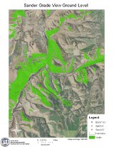
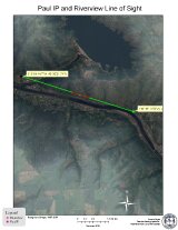
The first image is a view shed for one of our proposed towers for broadband coverage of the entire reservation. The green areas mean that if you are in this area, you can get a signal from that tower. The second map is the line of site from one tower to another. the red is not able to read the tower while the green is good, but any blockage means no signal from tower to tower.
I am certainly not the only expert out there and would love to know what others are doing as I am helping develop a community resource for Remote Sensing in Indian Country on the Indigenous Mapping Network website.
What it is that we really want to learn about?
I want to help facilitate this collaboration in any way that I can. That said, I could learn so much from you and plan to gather ideas from all the other groups out there to develop our project. Please take a moment to help identify what you’d like to see or want to contribute.
POLL http://bit.ly/8Z2U31
This project, an indigenous remote sensing community, is in its infancy; we seek your assistance in helping it grow. Our goal is that it can become a supplemental resource for remote sensing for Indian Country and possibly beyond. So please let us know what could help you most. Videos that highlight projects, articles of lessons learned, a blog or a forum to share ideas and seek help? I’ve put together a short poll to find out what might work for our tribal communities.
We have also set up a specific forum to enable an online dialogue. Volunteer moderators welcome! Partners welcome! Please email me at and let me know.
We also have a twitter account for catching remote sensing news as it comes in. We are looking for a Native American student as a volunteer social media intern, who can work from their home base to help manage (Indigenous Remote Sensing Community) and help develop the project. Please contact me or for the internship position.
Nomination Results of Tribal Members to NPS Cultural Resource Geospatial Standards Committee
Latest
Last Updated on Thursday, 16 September 2010 21:57 Written by Deidre McCarthy, posted by Rosemarie McKeon
I would like to thank the Indigenous Mapping Network for your extremely helpful participation in gathering Tribal representatives to provide technical advice and assistance to the Federal Geographic Data Committee cultural resource work group that the National Park Service, Cultural Resource GIS Facility is currently trying to form. I wrote several days ago asking for any volunteers who would like to participate and was overwhelmed with your kind and enthusiastic responses. I would like to thank each of you who wrote me a personal email, called or participated in the voting process that the IMN hosted. We are very grateful to the IMN for being willing to put together the voting process so quickly.Let me just clarify that the Federal Geographic Data Committee is not a Federal agency, but a committee whose members represent Federal agencies. We are simply seeking Tribal advice and technical assistance as we move forward in the creation of cultural resource spatial data standards. These standards and this work group are not directed toward any one Tribe, but we would appreciate having Tribal perspective in our discussions. Anything produced by the work group in the way of standards would only affect Federal agencies and it would be the choice of the Tribes to use the information generated or seek their own path.
The Cultural Resource GIS Facility sought out Tribal participation in the formation of this FGDC work group through other sources in the past but did not get many responses. It was suggested to us that we come to the IMN for help. Because of the overwhelming response that we did get through the IMN however we felt that it should not be the NPS or our office that chose Tribal representatives, but the Tribes themselves, which is why the IMN developed the voting system that many of you participated in. I provided the IMN with a list of all those who had volunteered directly to me so that the IMN could choose who they would like to participate in the work group to represent themselves. I provided the IMN with the information that each of the volunteers gave me, which is why some individuals have more background description than others.
In order to accommodate as many as we can in the small work group, we have offered to each Tribe or region represented, the opportunity to nominate one or several people. Regardless of how many names may be associated with a Tribe or region, that Tribe or region will have one vote. This is the same for each State and Federal agency. Each will have one vote when any decisions need to be made by the committee. In this way, the Tribes can designate for themselves one person to voice their vote, but can have several people to participate in the process. This is why you saw one or two names listed for a single Tribe in the voting.
The work group members are:
- Robert Thrower (Poarch Band of Creek Indians)
- Jill Wagner/John Hartman (Coeur d'Alene Tribe)
- Sandra Gaskell (Southern Sierra Miwuk)
- Jeff Cronce (Nez Perce Tribe)
- Elaina Albers (Yurok Tribe)
- Vernalee Grant (San Carlos Apache Tribe)
- Dawn Sherk (White Earth Nation)
- David Wyatt (Eastern Band of Cherokee Indians)
- Navajo Nation (to decide/share between three people)
- Alaska – Denise Rankin (Qawalangin Tribe of Unalaska) (to decide/share between three people)
Peer member recommendations that were identified in the voting effort or through direct email enquiry include:
- Alaska - Jacob Ivanoff, GIS, Bering Strait NSEDC; Bob Sattler, Staff Archaeologist, Tanana Chiefs Conference
- Northwest - David Lewis, Confederated Tribes of the Grande Ronde
- Pacific - Mike Connolly, Campo Band of Kumeyaay Indians; Patricia Ann Garcia-Tuck, Director/THPO, Agua Caliente Band of Cahuilla Indians
- Rocky Mountain - Don Sam, Confederated Salish and Kootenai; Don Aragon, Wind River Reservation; Little Shell Tribe of Chippewa Indians of Montana; John Murray THPO Blackfeet Tribe
- Southwest - India Lou Comosono, Archives-GIS, Pueblo of Zuni; Holly Houghten, THPO and Earl Bell from Mescalero Apache Tribe; Ute Mountain Ute Tribe
- Great Plains - Jhon Goes In Center, Oglala Lakota Tribe of the Pine Ridge Reservation; Brady Grant, THPO, Turtle Mt Reservation; Debra Dirlam, Office of the Environment Director, Lower Sioux Indian Community; Spirit Lake Sioux; Marcie Carter
- Southern Plains - Karen Kaniatobe, THPO, Comanche Nation; Harlan McKosato; LaDonna TallBear, GIS/GPS Technician, and Eleanor Lefthand Bianchi, Elder, Cheyenne & Arapaho Tribes of Oklahoma
- Eastern Oklahoma - Terry Cole, THPO, Choctaw Nation of Oklahoma; Darin West, Environmental and Natural Resources Dept, Osage Nation; Frank Harjo, Muscogee (Creek) Nation; Nancy John, Cherokee Nation
- Midwest - Matt Eitrem, Bad River Tribe
- Northeast - Tina Pierce, Nanticoke Lenni-Lenape; Arnold L. Printup, THPO, The Saint Regis Mohawk Tribe
To those of you who volunteered but did not end up in the work group, we value your opinions greatly and hope that you would consider participating in the larger peer group.
The peer group would not be involved in the heart of the work group activities, but would be able to review and comment on anything that the work group produced. Once again I must thank the IMN for providing a forum for this peer group to continue discussing amongst yourselves and listening and commenting to what the work group is doing.
I would encourage you to register for the forum by joining that peer group, which will remain open to as many of you who would like to participate. It will continue to grow throughout the entire process. The effort by the Cultural Resource Standards Committee could take about three years.
The list of those who have already registered in the forum, who are part of the work or peer group, is available on the IMN and can be found here:
If you do not see your name and you are a work or want to be a peer group member, please join the online dialogue at
Once the work group is finalized, I will organize a teleconference for the work group to orient everyone, introduce the FGDC, introduce the concept of spatial data transfer standards and update everyone on the basic principles that were outlined in 2009 in our initial meeting of Federal agencies as well as State and Tribal Historic Preservation Officers. From there, we hope that the work group can develop a work plan and take a look at the FGDC standard creation process. I hope to hold that meeting in late September or early October 2010.
Once again I would like to thank the Network and all of those who volunteered to be part of this process, either through the work group or the peer group. We are grateful for your advice and perspective. I will continue to keep the IMN informed via the forum regarding anything that the work group does. If you have any questions, please let me know: .
We look forward to continuing to work with the IMN!
Thank you,
Deidre McCarthy, GISP
Cultural Resource GIS Facility
Heritage Documentation Programs
National Park Service
More Articles...
- Responsible Gambling in Australia: Tools and Tips for Online Casino Players
- Esri Nonprofit Organization Program - Nonprofits serving Tribal Communities
- Seeking Tribal Representatives to Participate in Creating Federal Agency-wide Cultural Resource Spatial Data Standards
- Native American Friends - Get Ready for Geoscience Alliance 2010
[email protected]
Page 1 of 29
- Start
- Prev
- 1
- 2
- 3
- 4
- 5
- 6
- 7
- 8
- 9
- 10
- Next
- End
