Remote Sensing
Introduction: Remote Sensing in Indian Country
Last Updated on Sunday, 26 September 2010 20:06
Have you ever wondered how remote sensing could supplement your work?Wondered about what other tribes are doing with this technology?
Where to get training or more information outside of vendors?
Hi, my name is Laurie Ames and I am the Remote Sensing Specialist for the Nez Perce Tribe. We are housed in the Land Services office and provide GIS and remote sensing support to various tribal departments. While I don't usually 'do' the actual project, I do work closely with the project leader. I have been the Remote Sensing person here for over eight years. I've gained some perspective and knowledge of what is going on and how things have progressed in the area of indigenous remote sensing. Here are two examples of my work:
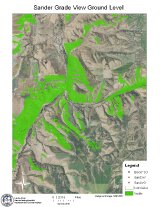
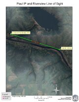
The first image is a view shed for one of our proposed towers for broadband coverage of the entire reservation. The green areas mean that if you are in this area, you can get a signal from that tower. The second map is the line of site from one tower to another. the red is not able to read the tower while the green is good, but any blockage means no signal from tower to tower.
I am certainly not the only expert out there and would love to know what others are doing as I am helping develop a community resource for Remote Sensing in Indian Country on the Indigenous Mapping Network website.
What it is that we really want to learn about?
I want to help facilitate this collaboration in any way that I can. That said, I could learn so much from you and plan to gather ideas from all the other groups out there to develop our project. Please take a moment to help identify what you’d like to see or want to contribute.
POLL http://bit.ly/8Z2U31
This project, an indigenous remote sensing community, is in its infancy; we seek your assistance in helping it grow. Our goal is that it can become a supplemental resource for remote sensing for Indian Country and possibly beyond. So please let us know what could help you most. Videos that highlight projects, articles of lessons learned, a blog or a forum to share ideas and seek help? I’ve put together a short poll to find out what might work for our tribal communities.
We have also set up a specific forum to enable an online dialogue. Volunteer moderators welcome! Partners welcome! Please email me at and let me know.
We also have a twitter account for catching remote sensing news as it comes in. We are looking for a Native American student as a volunteer social media intern, who can work from their home base to help manage (Indigenous Remote Sensing Community) and help develop the project. Please contact me or for the internship position.
Indigenous Remote Sensing Collaborative: Project Turnbuckle - Peter Poole
Last Updated on Tuesday, 16 March 2010 09:19
PROJECT NAME: Turnbuckle

Lead Organisations and Persons
The project is a collaboration between Peter Poole (Local Earth Observation) and Dana Slaymaker (Resource Mapping). Dana Slaymaker is responsible for technical development; Peter Poole for organising projected field training, testing, and manuals.
The decision to undertake this joint project is very recent and it is not yet funded.
PROJECT DESCRIPTION
In a historical perspective: this project attempts to reverse the criticism once regularly levelled at satellite-based remote sensing in the 1970’s - as a technology in search of an application. The imaging technique we have developed is exclusively applications-driven, and the ultimate goal of this project is to make this methodology also community-driven.
Strategy
The strategic goal is to amplify community control over the acquisition of environmental data, data by equipping them to gather their own aerial remotely sensed data and to control the process by which those raw data are converted to applicable information.
Tactics
Specifically , to develop an improved version of the aerial imaging system tested in the course of 13 training surveys with Maya and Garifuna conservation groups in Toledo, Belize, described in the attached report “Information; the First Conservation Asset”.
To operationalise that Toledo Mk2 imaging system in the context of four technology transfer and training projects, based on the collaborative model that evolved in Belize. The first in Toledo; the others in the Pacific, Eastern Africa, Canada/USA (in any order).
Following the Belize approach, each project will be organised as a collaboration with community-based groups that have acquired capacities in GIS. The groups will determine the data-gathering priorities that frame the training exercises and will subsequently learn how to plan data acquisition missions, operate the system in the air and process the data
Responsibilities
RM and LEO can assume responsibilities for technical development, and for the induction of a Toledo Mk2 system into a community GIS setting: training in survey planning, data acquisition, post-mission processing and downloading raw data to a GIS, backed up with manuals. We would seek to leave one unit at each site, for collective use.
Applications-Driven Development
Besides traditional applications such as habitat mapping, wildlife census or detecting illegal logging and mining, we shall introduced applications specific to the rapidly evolving environmental services industry. Dana Slaymaker is working on a powerful technique for estimating carbon sequestration potential from stereoscopic light aircraft aerial imaging. Such accurate site-specific serial data is vital if communities are going to prevent what is beginning to happen in many remote indigenous territories: remotely controlled asset-stripping by the environmental services industry.
Toledo Mk2 Aerial Remote Sensing Unit - from www.resourcemappinggis.com
The Toledo Mk2 imaging system is derived from the high end unit developed by Dana Slaymaker: “an external aerial camera mount that combines both multispectral and natural color cameras with a profiling laser altimeter, differential GPS, and inertial navigation system (INS). Contained in a modular pod that attaches to the window frame of any high-wing aircraft. These instruments automatically georeference digital imagery by projecting the position and orientation of each camera exposure to the surface, constructing accurate orthophoto mosaics without additional ground control points”
The Economics of Image Acquisition from Light Aircraft.
Taking image resolution and cover into account, data acquired in Yukon cost 70% less than Ikonos satellite imagery. In the Philippines, the data cost 50% less than Quickbird imagery. The key is logistics; contingency pre-planning of all surveys within 150-200 kms and real-time selection to maximise camera-on time and minimise weather effects.
Opportunities for Collaboration
The next, phase, dissemination via networks is not something that we are equipped to undertake. It makes far more sense to link up with existing networks. This is a potential start point for joining forces with the Indigenous Remote Sensing Collaborative.
The objective is not only to leave behind a new set of skills and a Toledo Mk2 imaging system for shared use, but for these projects to act as catalysts within the region, focal points to dissemination to indigenous communities through the region.
Indicators of success: Four community remote sensing centres positioned to collaborate with and build capacity for other indigenous GIS and stewardship groups in the region.
CONTRIBUTIONS TO THE FIELD
Toledo Mk2 components are off-the-shelf. Their integration into a high performance but low cost system sets a new marker for the rest of the field. But, brilliant as the image acquisition system is, the more significant contribution will be how these images are used afterwards. The Toledo project confirmed the image acquisition part, and opened up the possibilities for the image application part. The first of the three contributions below was an unintended consequence of the Belize project; the others are now coming into view.
Open access to geocoded imagery. In the Belize case we left behind an open access library of 3,500 images of Toledo District, freely available to all community members.
This system enables communities to acquire, analysis and apply their own remote sensing data tailored to meet their information needs rather than depend upon external sources.
The data is formatted to facilitate exchange between indigenous GIS and resource groups, and global environmental monitoring agencies that rely on a flow of accurate serial data.
PARTICIPATION LEVEL
Dana Slaymaker is already slated to make a presentation at IGARSS 2010, of the advanced data acquisition system from which Toledo Mk2 is derived.
A further possibility is that we give joint presentation. Dana would present the Toledo Mk2 Unit. I would present upon its manifold applications, of which I have many visuals and the options for training and technology transfer to a community context.
Another option would be to track the sequence of four projects on the websites.
LINKS AND ILLUSTRATIONS
Attached is the report on the Belize project, using the Toledo Mk1 combine.
Also a document which is still in draft but illustrates a number of applications of aerial imagery for First Nations communities in Canada, Suriname, Ecuador, Belize. The (out-dated) cover page is from a Local Earth Observation brochure prepared for the 1992 Earth Summit.
In the proposed four projects, we shall be working with the same Maya and Garifuna groups as in the earlier, but will be inviting participating from indigenous community-based groups in Honduras, Guatemala, Nicaragua and Mexico.
The Pacific project will be a collaboration with the Locally Managed Marine Area network, of over 400 community-managed coastal conservation areas. LMMA was represented at the Belize project.
The Eastern Africa project will be a collaboration with a number of pastoralist communities and associations who have set up their own community conservancies, or wish to do so. These include Mursi, Bodi and Suri pastoralists in Ethiopia, Samburu, Rendille and Maasai in Kenya and Tanzania – and possibly Ngok Dinka in southern Sudan. The fourth suggestion, USA/Canada would be left to the IMN
CFP: Indigenous Mapping Network's Remote Sensing Collaborative

Last Updated on Monday, 21 December 2009 09:07 Written by Rosemarie McKeon
To do this, it will solicit, select, and guide projects that demonstrate ways in which indigenous communities can perform and participate in community remote sensing. These may include efforts as simple as creating photographic records that formally document local environmental change or as sophisticated as validating satellite imagery to help ensure global environmental analyses accurately reflect the actual environment at local scales. IRSC will work with indigenous communities to help define appropriate project proposals and to ensure the success of selected projects. During the coming year, it will also work with IGARSS to promote selected projects on the IGARSS website, create collaborations with related IGARSS projects, and enable participation in the IGARSS conference.
Within IRSC, projects are sought from indigenous communities who would like to share their use of remote sensing. Project leads are encouraged to review projects on the IGARSS Community Remote Sensing website to learn from the techniques presented, and form collaborations with other projects as appropriate.
Selected projects will be posted on the IGARSS Community Remote Sensing website and to IndigenousMapping.Net, under its new "remote sensing" category. Student volunteers will assist in reviewing, publishing, and updating online projects. Each project includes a brief description, what it hopes to accomplish, key participating individuals, tribal nation, NGO or other institution working with an indigenous community; funding sources; and whether they will be presenting at the IGARSS Conference.
DEADLINE EXTENDED TO DECEMEBER 3OTH, 2009.
SUBMISSION FORM (PDF)